Part Two: Mobile Data Collection Technology Defined

The Technology Behind Mobile Data Collection
Advancements in mobile data collection leverage cutting-edge technology to gather critical data.
In part one of our series, we defined key terms to help you navigate proposals or choose a partner for roadway mobile data collection. This post explores the cutting-edge tools and methods used to analyze extensive roadway networks and their assets.
In our fleet, every vehicle is ready to capture every detail of a roadway network, from pavement conditions to assets such as signage, curb cuts, sidewalks, trees, streetlights, and roadway markings. This sophisticated setup, featuring technology worth hundreds of thousands of dollars, is calibrated to deliver precise and actionable data to meet the needs of our clients.
Read on to learn about the latest technology used in mobile data collection.
The Technology Used for Mobile Data Collection
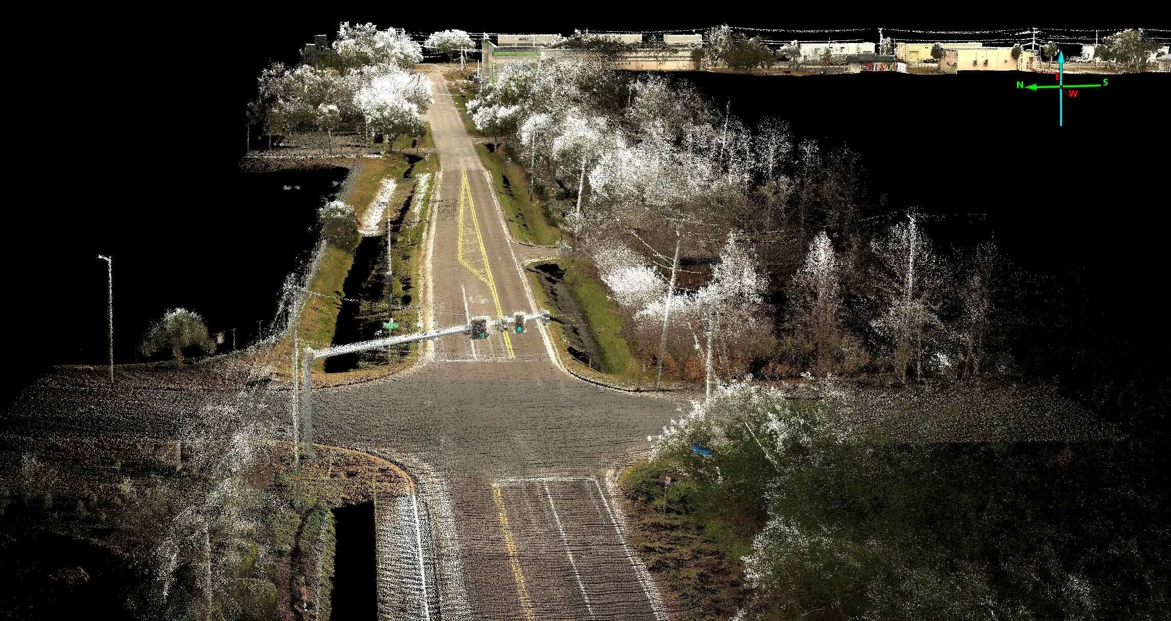
At Transmap, our data collection vehicles are outfitted with advanced tools such as 360-degree cameras, LiDAR, and Distance Measuring Instrument Systems. These technologies work to gather thousands of data points, enabling us to organize, analyze, and produce the most accurate asset and condition maps in our industry.
Panoramic 30MP Camera
Panoramic cameras utilize four or more triggered lenses to capture 360-degree images simultaneously. These images are then digitally stitched together to create a seamless 360-degree view—like Google Street View. This technology captures visual data on roadway conditions, such as cracking, rutting, and broken pavement. It is also instrumental in contextualizing roadway conditions, conducting asset inventories, and assessing curb conditions and other roadway features.
HD LiDAR
HD LiDAR (High-Definition Light Detection and Ranging) uses a spinning laser to scan a specific corridor. The laser captures objects with reflective surfaces, creating a detailed 3D environment that includes signage, trees, man-hole covers, and more. The scanner measures reflectivity, intensity, and distance, providing precise data for analysis. HD LiDAR is a critical tool for our Asset Management operations, offering unparalleled detail and accuracy.
Orthophotography and CrackMap Technology
Orthophotography combines the details of aerial photography with the geometric accuracy of a map. Unlike standard aerial photos, orthophotography removes distortions caused by elevation changes—such as hills, valleys, and buildings—ensuring all ground features are displayed in their actual geographical positions for precise measurements of distances, areas, and angles.
At Transmap, we employ ground-based LiDAR and CrackMap 3D technology to create detailed, street-level GIS data. This process enables the production of highly accurate, ground-based orthophotographic images, essential for advanced roadway and asset analysis.
Geo-Tagged Data
Geo-tagging involves adding geospatial metadata, such as coordinates, to images and datasets, enabling precise location identification. Using LiDAR technology, a spinning laser detects reflective surfaces and captures data, including width and height measurements. Reflectivity is assigned a number on a scale of 0 to 100, and GPS coordinates are geo-tagged to specific points.
This process geo-tags features like pavement conditions, roadway markings, hydrants, curb cracks, and other elements. The resulting GIS data is highly detailed and allows for efficient search. For instance, you can easily determine the exact number and location of signs, traffic signals, and handicap ramps at a specific intersection. Geo-tagging provides the accuracy and resolution necessary to answer location-specific questions.
LCMS2 Camera
An LCMS2 (Laser Crack Management System) camera is mounted on the rear of our mobile data collection vehicles. It captures detailed measurements of cracks, ruts, and various types of pavement distress, collecting up to 4,000 data points per lane. Its ultra-high-speed laser fires every 5 millimeters of vehicle movement and can accurately record data at speeds of up to 50 mph.
LCMS Pavement Distress Collection
Once pavement distress data is collected, it is organized and converted into XML raw data files. These files are then processed using specialized programs to generate reports, including PCI (Pavement Condition Index) assessments, rutting maps, and more.
The LCMS system integrates a camera and high-speed laser, making it a powerful tool for collecting detailed pavement distress data efficiently and accurately.
LCMS MrSID
MrSID is an advanced compression algorithm designed to reduce the size of large orthophotography images by removing unnecessary data. This technology creates manageable, high-quality files that are easy to store, share, and search.
At Transmap, we use MrSID with CrackMap orthophotography to produce searchable visual files. These compressed files are a standard deliverable included with every project, offering clients a practical and efficient way to access and analyze roadway condition information and network data.
SLICER
SLICER is the web-based front-end of the PAVER software, designed to provide easy access and interaction with PAVER data. It allows users to retrieve specific data points for review, offering detailed visual information on features like pavement cracking, signage, sidewalk conditions, and PCI (Pavement Condition Index) data.
Through its web GIS capabilities, SLICER serves multiple purposes:
Delivery Tool: Provides project data to customers in an accessible format.
Organizational Tool: Streamlines project management by creating and organizing data maps.
Real-Time Tracking: Monitors data collection vehicles live.
Field Data Collection: Supports efficient data gathering in the field.
SLICER is the central interface for customers, combining project management, field operations, and data visualization into one cohesive platform.
DMI (Distance Measuring Instrument)
The Distance Measuring Instrument (DMI) Wheel Counter is a high-precision tool installed on our trucks to measure roadway section lengths. It consists of a glass disc with a laser that accurately counts each wheel rotation. The DMI is constantly calibrated to ensure accuracy and provides exact measurements for data collection.
Looking Ahead
Understanding the technology behind mobile data collection gives agencies insight into how we gather and deliver critical information, helping them make informed decisions during the proposal process and throughout the project. In our next installment, we’ll dive into the science of distress identification.
Transmap is a nationwide provider of professional pavement, roadway, and asset management support services to cities, counties, and municipalities. Using our advanced technologies, we provide excellent customer service and robust full analysis. We are dedicated to maintaining this high standard of data quality while also reducing data collection costs for our clients. To learn more, contact our main office in Columbus, OH, at (614) 810–1235.