How Colorized LiDAR Delivers a New Level of Asset Data
Traditional LiDAR
Colorized LiDAR: Smart Pano Elite Delivers a New Level of Asset Data
Roadway data collection has moved far beyond traditional surveys and manual inspections.
Today’s agencies need infrastructure data that is accurate, easy to visualize, and useful for informed decision-making. As asset management programs become more sophisticated, the need for detailed, actionable information continues to grow.
Transmap’s Smart Pano Elite System combines high-definition LiDAR with high-resolution panoramic imagery to create Colorized LiDAR. By applying real-world color from panoramic images to millions of LiDAR data points, the system produces detailed 3D representations of roadway corridors and infrastructure assets.
Learn how Colorized LiDAR offers agencies a richer dataset that improves asset identification, enhances project planning, and provides a clearer understanding of roadway conditions.
What is LiDAR?
Light Detection and Ranging (LiDAR) is a remote sensing technology that uses laser pulses to measure distances between a sensor and surrounding objects. As the system travels along a roadway, it emits millions of laser pulses and records how long each pulse takes to return. These measurements are then used to create highly accurate three-dimensional representations, known as point clouds, of the roadway environment.
For transportation agencies, engineers, and asset managers, LiDAR has become an essential tool for quickly and efficiently collecting detailed infrastructure data. Its ability to capture millions of measurements per second allows for precise mapping of roadway corridors, pavement features, and roadside assets.
The resulting data supports a wide range of applications, including asset inventories, engineering analysis, and GIS integration. By providing an accurate spatial record of infrastructure conditions, LiDAR helps agencies make more informed decisions about maintenance, planning, and future investments.
The Limitations of Traditional LiDAR
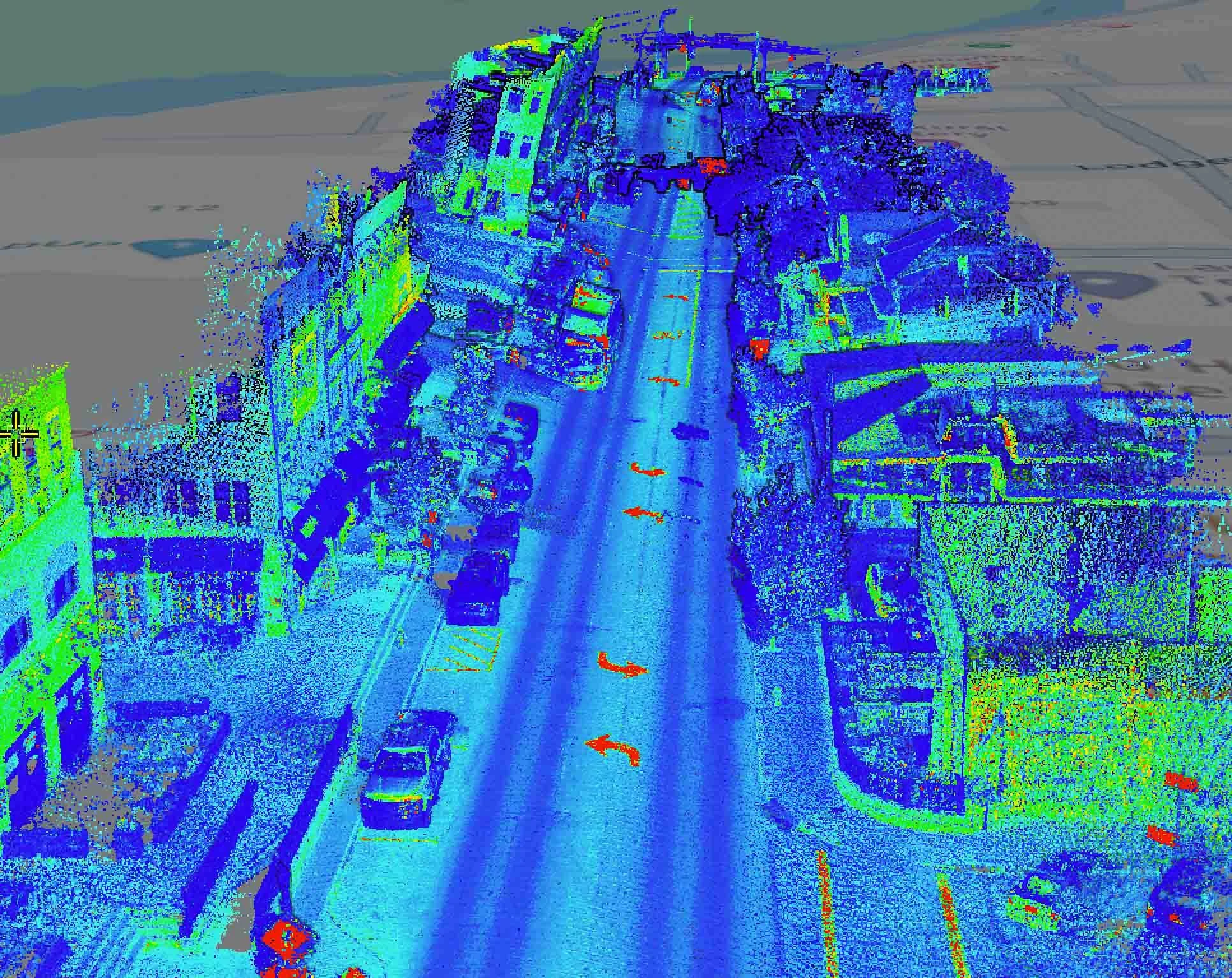
While traditional LiDAR provides highly accurate spatial data, the resulting point clouds can be difficult to interpret. Most LiDAR datasets are displayed in grayscale or elevation-based colors, creating a dense collection of points that often lacks the visual context needed for quick understanding.
For engineers and GIS professionals, these point clouds contain valuable information. However, non-technical users may struggle to identify specific assets, distinguish between materials, or assess visual conditions from the data alone. Determining whether an object is a sign, guardrail, sidewalk, or utility feature requires additional analysis and processing.
As agencies collect larger volumes of infrastructure data, the challenge is no longer simply collecting information. It is about making that information easier to understand and use. This need for greater visual context has driven the development of Colorized LiDAR.
Colorized LiDAR
What is Colorized LiDAR?
Bringing Point Clouds to Life
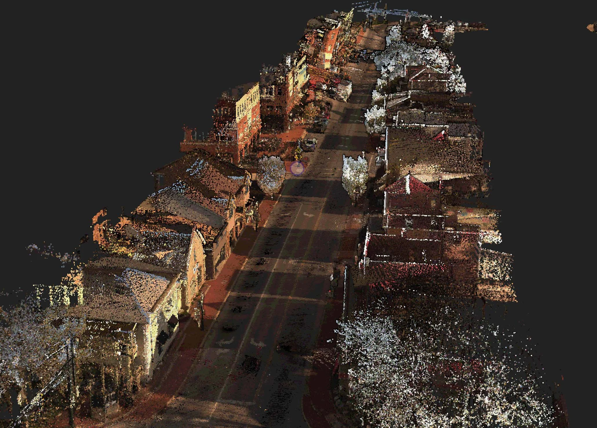
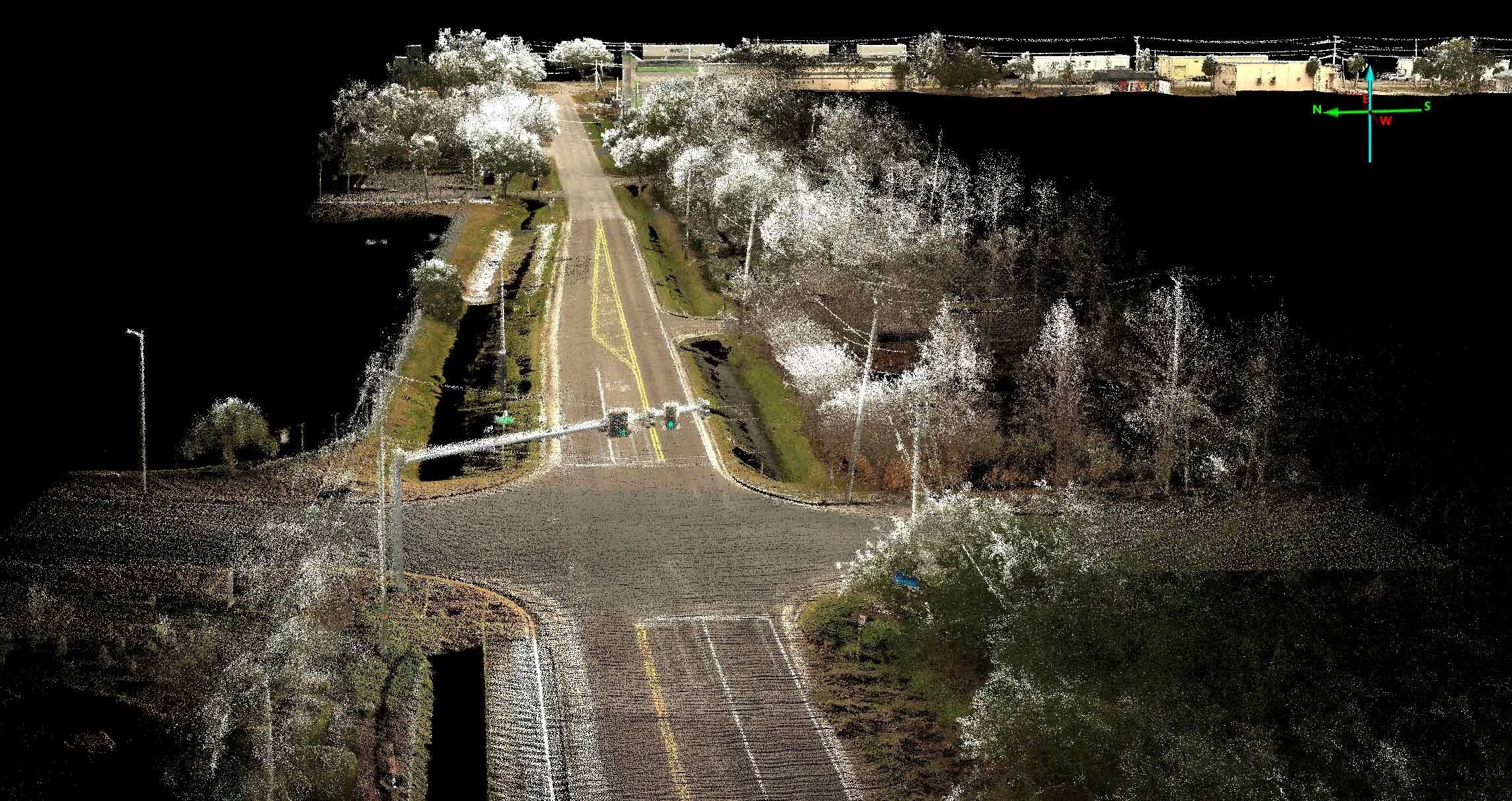
Colorized LiDAR enhances traditional LiDAR data by combining it with high-resolution images to create a more realistic, intuitive view of the roadway and environment. Instead of displaying point clouds in grayscale or elevation-based colors, each LiDAR point is assigned its true color using synchronized panoramic images captured during data collection.
The result is a highly detailed, full-color 3D representation of roads, sidewalks, signs, guardrails, utilities, and other assets. This added real-world visual context helps identify features, interpret roadway conditions, and analyze infrastructure with greater confidence. As a result, the data is not only highly accurate but also significantly easier to understand and use for planning, engineering, and asset management.
Why Color Matters
Adding color to LiDAR data does more than improve its appearance. It makes the information much more usable. By combining precise 3D measurements with high-resolution panoramic imagery, Colorized LiDAR provides the visual context needed to quickly understand roadway environments and infrastructure assets.
For agencies, engineers, and decision-makers, this means that data is easier to interpret and analyze. The added visual detail supports condition assessments, project planning, and communication with stakeholders by presenting data in an accurate, intuitive format.
Simply put, Colorized LiDAR transforms complex point clouds into actionable information, leading to better, faster decisions.
The Smart Pano Elite System
Transmap uses the latest version of the Smart Pano Elite System for data collection. The Smart Pano Elite is the next-generation mobile data collection platform designed to capture comprehensive, high-quality roadway and asset data in a single pass at normal highway speeds. By integrating high-definition LiDAR, high-resolution panoramic imagery, precision GPS positioning, and advanced data processing, the system delivers a complete digital view of transportation infrastructure.
Unlike traditional data collection methods that rely on multiple surveys or separate datasets, the Smart Pano Elite System simultaneously captures LiDAR and panoramic imagery while traveling at the speed limit. This synchronized approach ensures accurate alignment between spatial measurements and visual imagery, producing detailed Colorized LiDAR that provides both precision and context.
The result is a more complete representation of roadway corridors. This helps agencies efficiently inventory assets, including asset conditions, and make better-informed decisions based on accurate, visually rich data.
How Smart Pano Elite Creates Colorized LiDAR
The system creates Colorized LiDAR by combining precise spatial data with high-resolution panoramic images collected simultaneously. As the mobile data collection vehicle travels along a roadway, the high-definition LiDAR sensor captures millions of accurate 3D measurements while synchronized panoramic cameras record detailed real-world images of the surrounding environment.
Advanced processing software then uses artificial intelligence and machine learning to precisely align the imagery with the LiDAR point cloud, assigning the appropriate color to each individual point. The result is a highly detailed, full-color 3D representation of the roadway and its surrounding assets that combines the accuracy of LiDAR with the visual clarity of panoramic photography.
Because both datasets are captured together, they remain perfectly synchronized, reducing alignment errors and producing consistent, reliable results. This streamlined workflow improves data quality and accelerates processing, giving agencies faster access to the actionable information they need for planning, asset management, and infrastructure decision-making.
The Key Benefits of Colorized LiDAR for Agencies
Colorized LiDAR transforms complex infrastructure data into actionable information that is easier to understand and apply. By combining precise spatial measurements with real-world imagery, agencies gain a clearer picture of their transportation network, improving the accuracy of asset management, project planning, and decision-making.
Benefits include:
Improved Asset Identification – Colorized LiDAR makes it easier to locate, identify, and inventory roadway assets, including signs, guardrails, sidewalks, curb ramps, utility features, drainage infrastructure, streetlights, and traffic control devices.
Enhanced Project Planning – With a more realistic view of roadways, agencies can better visualize existing conditions, improving engineering and design support. Projects can be more effectively communicated to stakeholders and the public. This allows agencies to make more informed planning and investment decisions.
Greater Efficiency – Colorized LiDAR helps to streamline data collection and analysis in several ways. First, it reduces the need for repeat field visits. Accurate Colorized LiDAR data accelerates asset inventory identification, simplifies condition assessments, and improves data validation and quality assurance.
Better Collaboration – Because the data is clear and easier to interpret, Colorized LiDAR supports collaboration across organizations by making complex datasets accessible to both technical and non-technical users. This data provides valuable insights for consultants, engineers, planners, and public officials.
Real-World Applications
Colorized LiDAR provides agencies with a versatile dataset that supports a wide range of transportation and infrastructure initiatives. By combining precise 3D measurements with realistic visual context, it enables more informed planning, better asset management, and improved long-term decision-making.
Asset Management
Colorized LiDAR helps agencies create accurate, comprehensive inventories of roadway assets while supporting GIS-based asset management programs. With reliable, visually rich data, agencies can better plan maintenance, track asset conditions, and make informed lifecycle management decisions.
Pavement and Transportation Planning
The detailed 3D data provided by Colorized LiDAR gives planners and engineers a clearer understanding of their roadway networks. It supports corridor analysis, capital improvement planning, and roadway safety assessments, helping agencies prioritize projects and invest resources more effectively.
ADA Compliance
Colorized LiDAR simplifies the evaluation of pedestrian infrastructure by making it easier to identify sidewalks, curb ramps, and other accessibility features. This detailed information supports ADA compliance efforts and helps agencies plan accessibility improvements with greater confidence.
Digital Twins and Smart Cities
As transportation agencies adopt digital infrastructure management, Colorized LiDAR serves as a valuable foundation for creating realistic digital representations of roadway networks. These detailed datasets support digital twin developments and provide the accurate information needed to advance smart city planning and future infrastructure initiatives.
Why Colorized LiDAR Matters for the Future of Infrastructure Management
Agencies are collecting more infrastructure data than ever before. The challenge is no longer gathering information; the challenge has become turning that information into insights that are easy to understand and act upon. Colorized LiDAR bridges the gap between technical precision and visual clarity by combining accurate spatial measurements with realistic imagery, making complex datasets more accessible to engineers, planners, and decision-makers.
This added context leads to better decisions at every stage of infrastructure management. Agencies can evaluate existing conditions with greater confidence, prioritize maintenance and capital investments more effectively, and communicate project needs more clearly with stakeholders. By delivering richer, more intuitive datasets, Colorized LiDAR helps maximize the value of every data collection effort while supporting smarter data-driven infrastructure planning for the future.
Seeing Infrastructure in a New Way
Colorized LiDAR represents the next step in roadway and asset data collection, combining the precision of high-definition LiDAR with the visual context of panoramic imagery. Through Transmap’s Smart Pano Elite System, agencies gain realistic, data-rich 3D representations of their networks that are easier to interpret and more valuable for everyday decision-making.
From improving asset inventories and infrastructure assessments to supporting project planning and long-term investment strategies, Colorized LiDAR transforms complex data into actionable insights. As agencies continue to embrace smarter, data-driven infrastructure management, technologies like Smart Pano Elite provide the clarity, accuracy, and context needed to make better decisions faster and build more resilient transportation networks for the future.
Transmap is a nationwide provider of professional pavement, roadway, and asset management support services to cities, counties, and municipalities. Using our advanced technologies, we provide excellent customer service, accurate data collection, and robust, comprehensive analysis. We are dedicated to maintaining this high standard of data quality while also reducing data collection costs for our clients.
To learn more, contact our main office in Columbus, OH at (614) 810-1235.